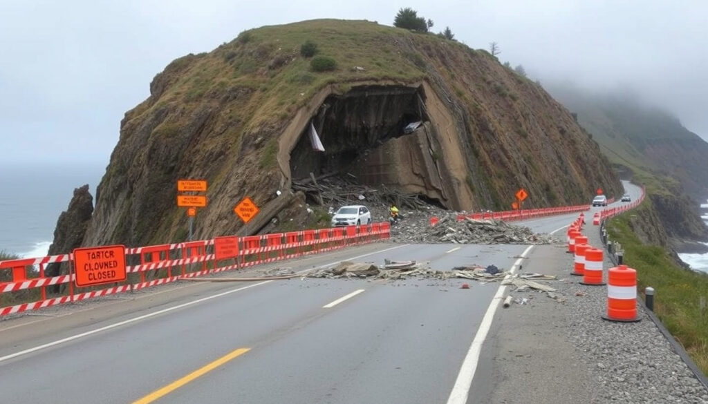
Rocks Road Slip Nelson: SH6 Closure, Detour, and Reopening Updates
If you’ve driven along Nelson’s coastline lately, you’ve probably noticed the barriers where Rocks Road meets the cliffs. A slip and rockfall on State Highway 6 shut down a vital commuter route between Bisley Avenue and Richardson Street, forcing drivers, cyclists, and bus passengers to find alternate routes. Here’s what happened, why the road closed, and when it reopened—straight from the official updates.
Road affected: State Highway 6 Rocks Road · Closure section: Bisley Avenue to Richardson Street / Russell Street · Reopening date: 18 July 2025 at 6 p.m. · Cause: Slip and rockfall
Quick snapshot
- Slip and rockfall closed SH6 Rocks Road between Bisley Avenue and Richardson Street (NZTA Journey Planner)
- Closure applied to all users including pedestrians and cyclists (NZTA Journey Planner) (NZTA Journey Planner)
- Exact date when the slip first occurred remains unconfirmed
- Long-term repair timeline and full cliff-face restoration plan not yet published
- Reopening announced for 18 July 2025 at 6 p.m. (Nelson City Council)
- Water-filled safety barriers and 30 km/h speed limit in place at slip site (Nelson City Council) (Nelson City Council)
- Roadside barriers will remain installed at the slip site after reopening (Nelson City Council)
- Ongoing monitoring of cliff face by NZTA geotechnical teams
Six key facts about the closure, one pattern: the slip event escalated quickly from a morning report to a full multi-day closure affecting everyone who uses this coastal route.
| Detail | Value |
|---|---|
| Road name | State Highway 6 (Rocks Road), Nelson |
| Closed section | Bisley Avenue to Richardson Street / Russell Street |
| Cause | Slip and rockfall / unstable material |
| Closure start date | On or around 6 July 2025 |
| Reopening date | 18 July 2025 at 6 p.m. |
| Managing authority | NZ Transport Agency (NZTA) and Nelson City Council |
What is the Rocks Road slip in Nelson?
Overview of the slip event on SH6
- A slip and rockfall on State Highway 6 Rocks Road triggered a full road closure between Bisley Avenue and Richardson Street / Russell Street (NZTA Journey Planner).
- The closure applied to all road users—vehicles, pedestrians, and cyclists (NZTA Journey Planner).
- Nelson City Council confirmed that contractors removed approximately 650 tonnes of unstable material from the cliff face during the operation (Nelson City Council).
Why is Rocks Road Nelson closed?
Cause of the slip: unstable material and rockfall
- Unstable material on the cliff face above Rocks Road triggered the slip and subsequent rockfall, making the road unsafe for any traffic (NZTA Journey Planner).
- A specialist abseiling team was brought in to remove unstable sections from the top of the cliff before the road could be deemed safe (NZTA Journey Planner).
- NZTA stated the road would remain closed “until it is safe to reopen” (NZTA Journey Planner).
Even after the road reopens, water-filled safety barriers and a 30 km/h temporary speed limit remain in place at the slip site—meaning the hazard isn’t entirely gone, just managed.
Where exactly is the Rocks Road slip located?
Map of the closure area
- The slip is located on SH6 Rocks Road between Bisley Avenue and Richardson Street / Russell Street in Nelson (NZTA Journey Planner).
- This section runs along the coastline near Wakefield Quay, a popular area for restaurants and walking.
Specific intersection: Bisley Avenue and Richardson Street
- The closure boundaries were set at Bisley Avenue on one end and Richardson Street / Russell Street on the other (NZTA Journey Planner, Nelson City Council).
- People wanting access to restaurants on Wakefield Quay were directed to enter via Haven Road instead (NZTA Journey Planner).
The implication: this slip disrupted not just commuters but also the hospitality businesses along Wakefield Quay, which depend on easy roadside access.
When did the Rocks Road slip happen and when will it reopen?
Timeline of events from July 2025
- The slip was reported at approximately 8 a.m. on Friday 4 July 2025 (NZTA Journey Planner).
- On Sunday 6 July 2025, NZTA announced the road would open at 11:30 p.m. that night (NZTA Journey Planner).
- Further assessment work led to an extended closure while a specialist abseiling team removed unstable cliff-face material (NZTA Journey Planner).
Reopening scheduled for 18 July 2025 at 6 p.m.
- Nelson City Council confirmed the road would reopen to all road users at 6 p.m. on Friday 18 July 2025 (Nelson City Council).
- Roadside barriers will remain in place at the slip site after reopening (Nelson City Council).
- A 30 km/h temporary speed limit applies through the affected area (NZTA Journey Planner).
For daily commuters who rely on SH6 Rocks Road, the closure meant two full weeks of detours. The reopened road with barriers and reduced speed limits means travel times may remain longer than normal even after the official reopening.
Is Rocks Road closed to pedestrians and cyclists?
Who is affected: all road users including eBus Route 2
- Yes—the closure applied to all users: vehicles, pedestrians, and cyclists (NZTA Journey Planner).
- eBus Route 2 was diverted as a result of the closure (Nelson City Council).
- NZTA advised the detour for all traffic, including heavy vehicles, was via Waimea Road and Whakatu Drive (NZTA Journey Planner).
The pattern: Rocks Road is a narrow coastal corridor with no alternative parallel route—when it closes, the entire western approach to Nelson funnels onto Waimea Road, causing congestion for everyone.
Practical steps for commuters during the Rocks Road closure
Detour routes and alternatives
- For vehicles heading into Nelson: take Waimea Road and Whakatu Drive as the primary detour (NZTA Journey Planner).
- For access to Wakefield Quay restaurants: enter via Haven Road (NZTA Journey Planner).
- For cyclists and pedestrians: use the Waimea Road shared path as an alternative to the closed Rocks Road section.
- For eBus Route 2 passengers: check the Nelson City Council website for the current diversion routing (Nelson City Council).
- Allow extra travel time: NZTA warned that congestion was expected on alternative routes (NZTA Journey Planner).
Timeline section
- 4 July 2025 (approx. 8 a.m.): Slip reported on SH6 Rocks Road; road closed between Russell Street and Bisley Avenue (NZTA Journey Planner).
- 6 July 2025: NZTA announced the road would open at 11:30 p.m. that night (NZTA Journey Planner).
- Mid-July 2025: Assessment and cleanup work ongoing; specialist abseiling team removed unstable cliff material (NZTA Journey Planner).
- 18 July 2025: Road reopened at 6 p.m.; barriers and 30 km/h speed limit in place (Nelson City Council).
The trade-off: NZTA prioritised thorough cliff-face treatment over speed, meaning a longer closure but a safer reopening. The 650 tonnes of removed material is the clearest measure of how serious the instability was.
Clarity section
Confirmed facts
- SH6 Rocks Road closed between Bisley Avenue and Richardson Street / Russell Street due to slip and rockfall (NZTA).
- Reopening set for 18 July 2025 at 6 p.m. (Nelson City Council).
- Closure applied to all users including pedestrians and cyclists (NZTA).
- eBus Route 2 affected (Nelson City Council).
- Approximately 650 tonnes of material removed from cliff face (Nelson City Council).
What’s unclear
- Exact date when the slip first occurred.
- Whether the slip site is fully stable after reopening.
- Long-term repair plans and timeline for full restoration.
- When the temporary barriers and 30 km/h speed limit will be removed.
The confirmed facts outweigh the unknowns, but the lack of a long-term repair timeline remains a concern for residents.
“State Highway 6 Rocks Road between Russell Street and Bisley Avenue is CLOSED due to a slip.”
NZTA Journey Planner (official traffic bulletin)
“State Highway 6 Rocks Road will reopen to all road users at 6 o’clock tonight. Roadside barriers will be in place at the slip site.”
“Contractors removed approximately 650 tonnes of material from the cliff face to make the site safe.”
Nelson City Council media release
Summary
The Rocks Road slip shut Nelson’s most direct coastal route for nearly two weeks, affecting everyone from daily commuters to bus passengers and hospitality businesses along Wakefield Quay. While the road has now reopened with safety barriers in place, the 650 tonnes of removed material and the ongoing 30 km/h speed limit signal that full stability remains a work in progress. For Nelson residents, the message is clear: allow extra time on the Waimea Road detour until the barriers come down, and keep an eye on NZTA updates for any further cliff-face work.
youtube.com, facebook.com, journeys.nzta.govt.nz, youtube.com, facebook.com, facebook.com, instagram.com, x.com, nzta.govt.nz
Frequently asked questions
Can I still walk or cycle on Rocks Road during the closure?
No—the closure applied to all users including pedestrians and cyclists for safety reasons (NZTA). Use the Waimea Road shared path as an alternative.
What is the detour for vehicles heading into Nelson?
NZTA advised all traffic, including heavy vehicles, to use Waimea Road and Whakatu Drive as the primary detour (NZTA Journey Planner).
How long will the repair work take after the road reopens?
No long-term timeline has been published yet. Roadside barriers and a 30 km/h speed limit remain in place at the slip site while NZTA continues monitoring (Nelson City Council).
Is there a map showing the closed section of Rocks Road?
NZTA’s Journey Planner website shows the closure boundaries at Bisley Avenue and Richardson Street / Russell Street (NZTA Journey Planner).
Who do I contact for more information about the slip?
Contact NZ Transport Agency (NZTA) via their Journey Planner website or the Nelson City Council customer service team for local road updates.
Will the slip affect bus services on Route 2?
Yes—eBus Route 2 was diverted due to the closure (Nelson City Council). Check the council website for current routing.
Are there any alternative routes to avoid Rocks Road?
Yes—Waimea Road and Whakatu Drive are the recommended detour for all vehicles. For Wakefield Quay access, use Haven Road (NZTA).
Has this section of Rocks Road had slips before?
Rocks Road has experienced slope instability issues historically due to the coastal cliff geology, though this July 2025 event was significant enough to require a full closure and specialist abseiling team intervention.
More related posts
 Authentic Raw Fish Recipe NZ: Ika Mata & Ota Ika Guide
 New Zealand Minimum Wage 2026: Rates Per Hour and Types
 India vs Australia Cricket Match Scorecard: Key Results & Stats
 House of the Dragon: Season 3 Release, Cast & News
 Alexandra Daddario Movies and TV Shows – Complete Filmography 2024
 Super Rugby Pacific Fantasy 2026: Guide, Tips & Player Picks
 Air New Zealand Booking: Online Flights & Tips
 Hard Words to Spell: 100+ Tricky Words and Their Correct Spelling
